A new installation opening at the New-York Historical Society provides a look at everyday life in New Amsterdam at the peak of its settlement. Marking the 400th anniversary of the Dutch colony’s founding, the installation “New York Before New York: The Castello Plan of New Amsterdam” centers around the Castello Plan, a historic map depicting New Amsterdam in 1660 right before the English took control. On view from March 15 through July 14, the installation also features rare documents and objects that explore the lives of settlers, Indigenous people, and enslaved Africans who resided in the colony.
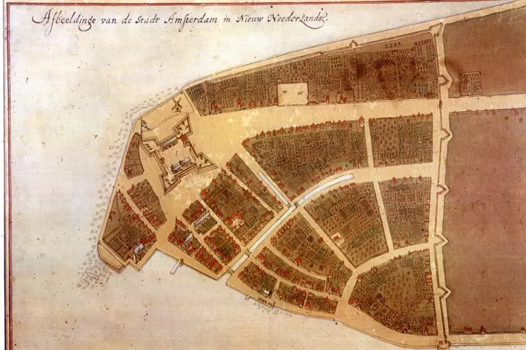
The Castello Plan, the main attraction of the installation was painted by artist Johannes Vingboons, the map is based on a surveyor’s plan commissioned by New Amsterdam’s leaders. The plan was sold to the Archduke of Tuscany, who hung it up in the Villa di Castello in Florence, Italy, where it was rediscovered in 1900.
The Castello Plan shows the city at its height and reveals incredible details, including gardens, docks, canals, and a windmill. The map shows roughly 1,500 inhabitants and about 300 houses stretched out across the colony, and thanks to an accompanying census, the names of the owners of each house are known.
“We’re very excited to share this rare glimpse into life in New Amsterdam as we mark the 400th anniversary of the city with our visitors,” Dr. Louise Mirrer, president and CEO of New-York Historical Society, said. “The Castello Plan, along with documents, coins, maps, and even a piece of the Dutch canal, will help visitors envision how New Amsterdam was a place of dynamism and opportunity as well as enslavement and hardship.”
Also on display is a letter sent by Dutch government official Pieter Schagen discussing the purchase of the island. The letter, on loan from the Hague in the Netherlands, is the only record that exists of the “purchase” of the land from the local tribe, who most likely believed the transaction was a land-use agreement and not one that permanently granted the land to the settlers.
Another artifact included in the exhibit is a mpungu, thought to have been created around 1660 by an enslaved person. Unearthed in 1984 by archaeologists at the home of Cornelis Van Tienhoven, Peter Stuyvesant’s secretary, mpungu means “to stick together” and refers to a collection of objects that central African cultures believed had healing powers.
The bundle of items features bone and shell fragments, marbles, nails, pieces of pipe stems and bowls, glass beads, a copper thimble, and other objects. The artifact was found in a basket buried in the ground covered with a Dutch plate. The mpungu is an example of how enslaved Africans in New Amsterdam continued their cultural practices in the face of adversity.
Accompanying the installation is a digital 3D version of the Castello Plan, created in partnership with the New Amsterdam History Center. The interactive map gives visitors the opportunity to explore specific locations depicted on the plan, including the original City Hall, a house where enslaved Africans lived, and the Lenape trail that would later become Broadway.
The installation is curated by Russell Shorto, director of the New Amsterdam Project at New-York Historical. The New Amsterdam Project explores the city’s origins and connects critical elements of its formative period, including themes of tolerance, free trade, race, and colonialism, to the world today.
“Having the historic Castello Plan visit modern-day New York City from its home in Florence, Italy, gives New Yorkers the opportunity to experience the rich history of their home town through the lens of those people who 400 years ago began this magnificent experiment in multi-cultural, big-city living, including the Indigenous, the African American, the Dutch and others, all of whom made up the vibrant and diverse tapestry that was New Amsterdam, and remains to this day as New York City,” Ahmed Dadou, Consul General of the Netherlands in New York, said.
Ticket purchases and more information on the installation can be found here.
RELATED:
- On this day in 1811, the Manhattan Street Grid became official
- New-York Historical Society expansion will feature new Democracy Wing
The post One of the earliest maps of Manhattan will be on display at the New-York Historical Society first appeared on 6sqft.


